 The Kasparov Traverse
August 26, 2005
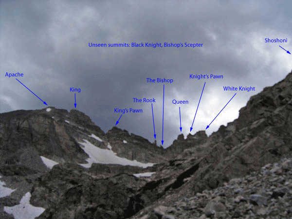
In Gerry Roach’s Indian Peaks guidebook he calls the gendarmes along the Shoshoni-Apache ridge the Chessmen. This traverse is rarely done and we know of no previous attempt to do this traverse and summit all the Chessmen. Roach describes and names two other classic traverses in the Indian Peaks: The Mohling and Pfiffner Traverses. Since these were names after regional mountain explorers, we named this traverse after a prominent chess explorer: current world chess champion Garry Kasparov.
We met in Boulder, early, and drove to the Long Lake trailhead. We were hiking by headlamp at 5:30 a.m., headed for Pawnee Pass. With us, we had a 50-meter, 9mm rope, climbing shoes, harness, a rack of cams and stoppers, slings, and even three summit registers, which Mark had made and we forgot to place on any summit. We also carried food, water, and extra clothes, of course. It was cold, probably in the 30's to begin with and maybe hit the 50's in the sun later in the day. I climbed the first two gendarmes with my gloves on.
Before getting to Pawnee Pass we traversed left across talus to gain the ridge leading to Shoshoni. Since we had both climbed Shoshoni before, we saved some time, bypassing the detour out to the summit and heading straight for the notch on the ridge between Shoshoni and Apache. Approaching this notch is very intimidating, but the descent goes nicely with mostly 3rd class scrambling and maybe some short 4th class sections. The exposure isn't too bad here either. We started the descent by going to the highest point on the ridge. Once or twice we had to backtrack slightly to continue down, but soon we were headed up to our first gendarme. Though we still hadn't hit the low point on the ridge, there were summits to climb.
The Kasparov Traverse
Not being aware of any names (official or otherwise) for these gendarmes, we named each one using the Chessmen theme. On each summit we built a cairn to mark our ascent.
Mark Oveson:
We traversed on the east side of the first tower to a likely spot, dropped our packs, and ascended a well-featured 4th-class face to a saddle. A short ridge scramble brought us to our first summit of the day. Feeling industrious, we built a cairn to mark our achievement. Or were we marking our territory? The instinct to spray is strong, and besides, we were out to name some towers, so we had to prove we had been there. We returned to the saddle and scrambled up to the petite southern summit of the formation. These were easy towers and served as a good introduction to our day. The initial summit with its long, narrow ridge quickly took on the name "White Knight," and it seemed appropriate that its pinpoint companion should be the "Knight's Pawn." Regaining our packs we moved on, anxious for what lay ahead. The views from our first summits had given us an appreciation for the number of towers we might be able to climb on our route.
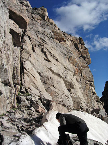
Dropping packs at the start of the climbing for the White
Knight
The Chessmen Ridge, on this morning at least, had a distinct schizophrenic quality. The east side of the ridge was sunny, calm, and dry. On the west, however, the cold wind blew, the rock was shadowy and damp, and the whole outlook on the day seemed bleak. Needless to say we spent as much time as possible on the east side of the ridge, and this brightened our spirits.
We began our ascent of "Tower 3" from the east as well, finding another scrambling ascent just a bit longer and more serious than the last. In this way the Chessmen lured us into a sense of security, and we didn't even discuss getting out the rope. The rock was again characteristically dry, solid, and featured, with only the occasional loose block to keep us wary. This third summit was stunning and the view was the best of the day so far. The regal stature and position of this third summit lent itself to its logical name, "The Queen."
Descending to our packs at the base of the Queen was only the beginning, and soon we embarked on the long descent to the low point of the ridge. A little routefinding here kept things interesting, and the ridge scrambling was spicy without being terrifying. We were learning the Kasparov rule of thumb: If you are stumped, look around until you find a navigable ledge, which is more than likely below you.
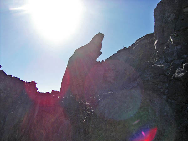
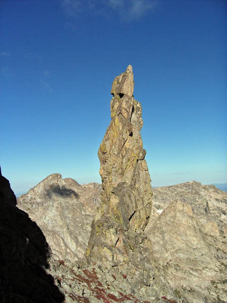
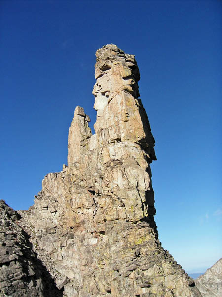
Our descent gave us plenty of opportunity to view the upcoming towers, and there was plenty to see. Hunched near the low point was our next objective, a strange little tower with a distinctive profile that we would eventually name The Bishop. To the west of the Bishop was a slender, 50-foot, pinpoint tower that looked impossible to climb. We would name this the Bishop's Scepter and beg the forgiveness of the Chessmen for the sling we left around its pretty summit block. Farther west, on the edge of a spur ridge, was a rugged and foreboding summit that would become the Black Knight. And dominating the view directly ahead was an awe-inspiring, round, leaning tower that simply had to be The Rook.
The Bishop - route
line
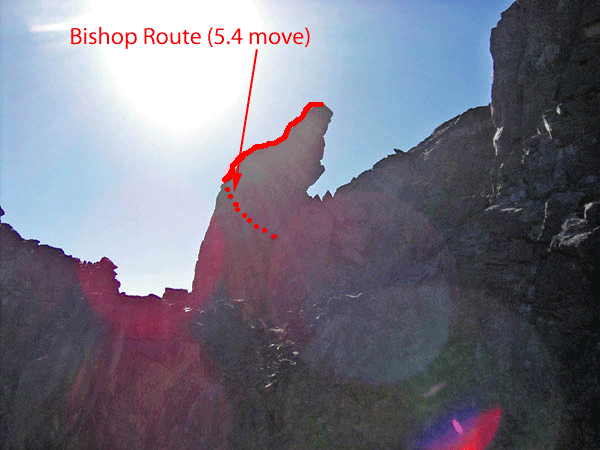
At the base of The Bishop we dropped packs again and studied the bouldery start. A few 5th-class moves brought us onto its north ridge, and then some slabby scrambling took us to the summit. This was our most committing climb of the day and for the first time Mark was outside of his happy zone. A fall from the Bishop would be most unpleasant.
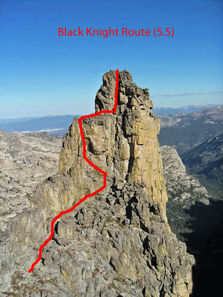
The Black Knight was next in line and from our vantage point, above and to the east, it looked to be an easier climb. We dropped packs at the base of the Bishop's Scepter and scampered over to the Black Knight's base. From here it looked larger and steeper than any tower we had yet climbed. Still, the rock was solid and holds appeared plentiful, so it had to be climbed. Rather than attack the tower directly underneath the summit, the less direct east ridge looked to provide a more rational climb. Taking each move with utmost caution we stemmed up the initial 40-foot dihedral and chimney system, which emptied onto a prominent shoulder. A short stroll took us to the summit tower, where a grungy chimney provided access to the top. The chockstones at the top of this chimney seemed suspect and we took special care not to yard on anything that wasn't connected to the tower. The Black Knight always triumphs, as any student of Monty Python can tell you, but today we stood on the summit
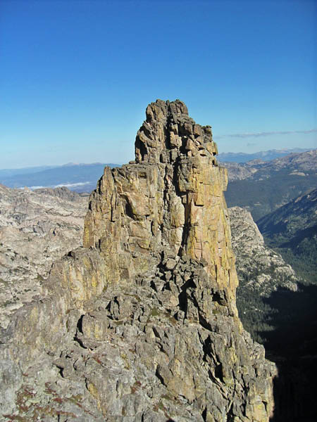
The Black Knight - route
line
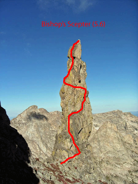
From the Bishop we had glimpsed these three towers, the Black Knight, Bishop's Scepter, and the Rook. They were slightly west of the Divide crest, but they were the most enticing summits of the day and we couldn't resist. The most impressive was a huge Rook, which I had noticed on my previous traverse of this ridge and the main reason I wanted to return for the summits. Standing before it, I wondered if there would be a climable route. The thinnest tower, the Bishop's Scepter, we almost rejected immediately, for it looked crazy. Now, with the Black Knight conquered, we took another look.
We donned harnesses, shoes, and got the rope out for the first time. I pulled on the rack and started up the southeast side. Surprisingly, I not only found solid rock, but great protection. Soon I was on top of the 65-foot gendarme. The top is merely a point and I just looped a single sling over the summit, clipped in two biners and lowered back to Mark. He then toproped the route. I felt the climbing was about 5.6.
The Bishop's Scepter (5.6) - route
line
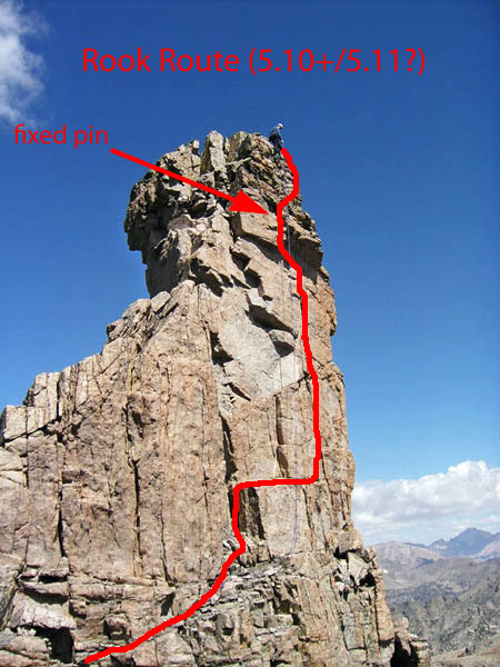
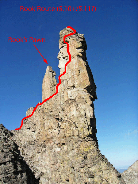
Finally, we turned out attention to the grand prize, a tower we named The Rook because of the resemblance and because I thought that sounded like a cool name. After reconnoitering every side, we finally found what looked like a weakness. After traversing into the notch between the Rook and it's subsidary spire (the Rook's Pawn?). Here I discovered that the route I thought I saw wasn't there. It was overhanging, compact granite with no chances for protection. I edged out onto the south face when Mark thought he spotted an artificial climbing aid up on that face. I also discovered a crack splitting this face and started up it. When it became very steep and very difficult, I started to look into a traverse to the right, but then I noticed a fixed pin above me and over the three-foot roof where my crack ended. I now knew the spire had been climbed before and that the route lay up the crack.
I continued up the crack, placing cams. Just before the roof, with scant footholds, I rested on a piece. The climbing above looked hard, but doable. I wasn't inclined to push things into the unknown in such an environment: way off the beaten path and on questionable rock. I continued up to and over the overhang all on natural holds, but rested on the next three pieces as well, including the fixed pin. Above here, I continued without gear on steep, questionable rock to the summit. I avoided the final steep section by a slight traverse to the right. The entire pitch was only half a rope length, but it was exciting, fun climbing. I think this spire would go free at 5.10+ or 5.11-. You'd just need the confidence to punch on through. Of course, the spire might have already been free climbed, as we know nothing about the previous ascent. Hence, our name for the spire is suspect as well since the first ascent team should name it. On top of the spire I found two fixed pins and belayed from them. Mark used a lot of ingenuity to gain the summit, including a loop of rope that I lowered to him in which he tied footloops. Mark doesn't climb at this level (nor do I, clearly), so he used a liberal amount of aid to gain the summit. We left three slings and two biners attached to the fixed pins as a rappel anchor and returned to the base of the spire. We were thrilled to have made the summit of this grand attraction.
The Rook (5.10+?) - route
line
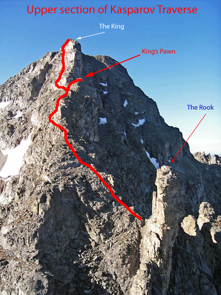
The rest of the ridge was great fun and yielded a few more summits, but the climbing was 4th class. We didn't use the rope again. The impressive tower that we had seen for much of the day, and which we named The King, proved to be easy and really more of a bump on the ridge than a tower, though it's northern escarpment is very steep and impressive.
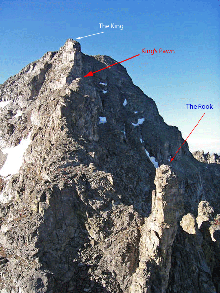
The King and the Rook - upper
traverse route line
We followed the ridge up over on last bump before travering over to the summit of Apache, where we signed the summit register. We decided to descend the Queen's Way couloir, figuring that the snow would be soft and it would provide an easy descent. This was not the case and we should have given up immediately, but stubborn and/or lazy, we continued down along some rocks and then out into the steep couloir. In our approach shoes we could barely kick a foothold in the hard surface. Without an ice axe, a fall could be fatal, as rocks lined the couloir. The runout seemed good, if we could just get past the constriction down below, but the runout also was littered with rocks. This couloir is near 40 degrees and speed would be gained instantly.
We each selected a rock and Mark ventured out into the couloir first, as I was too intimidated to go first. Seeing that Mark was making some progress, though slow and careful, I joined him. I used my big rock as an ice axe and reverse front-pointed down the couloir. I was either more confident or my rock was more secure for I quickly passed Mark by and led the way down the gully. Mark followed, using my footholds. Descending this gully was long, tedious, and dangerous. At one point, I dropped my rock! Thankfully, I was able to gain the other side of the gully and select another rock before continuing down. Eventually I got to the point where I could turn around and walk down forwards, plunging in my heels, though on just a bit. Finally, I sat down and started to glissade, but I was mostly down the steep section. Mark started his glissade from much further up and got going way too fast. He rolled over onto his belly and dug in his hands for all he was worth. He'd end up with completely numb fingers for the rest of the hike out, but he succeeded in slowing himself down and surviving.
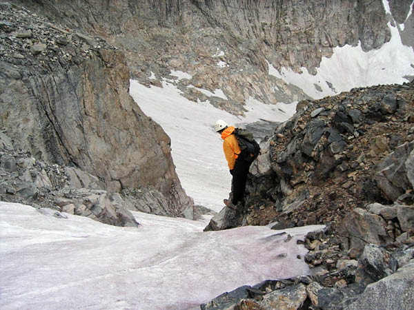
Contemplating the Queen's Way Couloir.
The rest of the hike out was beautiful and uneventful. We were tired and didn't bother with any running. We descended talus and picked up the Isabelle Glacier trail and followed it down to Isabelle Lake. Here, after ten hours in such a beautiful place only an hour from Boulder, we saw our first people. We returned to the car just under 11 hours after leaving it. It had been a great, successful adventure exploring summits in the Indian Peaks.
| Summit | Difficulty |
| White Knight | 4th class? |
| Knight's Pawn | 4th class |
| Queen | 5.2? |
| The Bishop | 5.5 |
| Black Knight | 5.5 S |
| Bishop's Scepter | 5.6 |
| The Rook | 5.10+/5.11- ?? Did not free |
| King's Pawn | 4th class |
| The King | 3rd class |